

“After the severe weather threat has passed from the Kansas City area, the storm system lingers, posing continued Flood Risk.
Following a highly active weather pattern on Saturday afternoon and evening, attention shifts to potential flooding overnight.”
“Expect periods of heavy rain overnight into Sunday, with a Flood Watch in effect until midday Sunday.
All forms of flooding are possible.
Stay updated with the First Alert Weather Team on Sunday morning for any potential development of storms by mid-morning.”
To read the Flood Risk summary click here
Flood Risk Overnight UPDATES
| Time | Update |
|---|---|
| 10:11 PM | Tornado Warning for Pettis County expires. |
| 10:01 PM | Tornado Warning for Johnson County, Missouri, canceled; warning for Pettis County remains. |
| 9:49 PM | Tornado Warning issued for Johnson and Pettis Counties in Missouri until 10:15 PM. |
| 9:44 PM | Tornado Warning for Henry, Johnson, and Pettis Counties expires. |
| 9:11 PM | New Tornado Warning for Henry, Johnson, and Pettis Counties in Missouri until 9:45 PM. |
| 8:59 PM | Carroll, Jackson, Ray Counties in Missouri, and Miami County, Kansas removed from Tornado Watch. |
| 8:54 PM | Cass County removed from Tornado Warning; warning continues for Henry and Johnson Counties in Missouri. |
| 8:48 PM | Trained spotter notes possible tornado on the ground near Montrose, Missouri. |
| 8:36 PM | Tornado Warning issued for Cass, Henry, Bates, and Johnson Counties in Missouri until 9:15 PM. |
| 8:15 PM | Tornado Warning issued for Bates and Cass Counties in Missouri until 9:00 PM. |
| 8:02 PM | Severe Thunderstorm Warning issued for Bates and Cass Counties in Missouri and Miami County, Kansas, until 8:45 PM. |
| 7:59 PM | Tornado Warning for Linn County, Kansas, expires. |
| 7:39 PM | Tornado Watch canceled for Clay County, Missouri, and Johnson and Wyandotte Counties in Kansas. |
| 7:29 PM | Tornado Warning issued for Linn County, Kansas, until 8:00 PM. |
| 7:21 PM | Severe Thunderstorm Warning canceled for Johnson County, Kansas. Tornado Watch canceled for Leavenworth County, Kansas, and Platte County, Missouri. |
| 7:05 PM | Severe Thunderstorm Warning issued for Cass, Jackson, and Lafayette Counties in Missouri and Miami County, Kansas, until 7:45 PM. |
| 7:03 PM | Severe Thunderstorm Warning for Wyandotte County, Kansas, canceled. |
| 6:44 PM | Severe Thunderstorm Warning issued for Cass and Jackson Counties in Missouri and Johnson and Wyandotte Counties in Kansas until 7:15 PM. |
| 6:21 PM | Tornado Warning issued for Linn County, Missouri, until 6:45 PM. |
| 5:15 PM | Grundy County removed from Tornado Warning; warning continues for Mercer, Putnam, and Sullivan Counties. |
| 5:07 PM | Tornado Warning issued for Grundy, Mercer, Putnam, and Sullivan Counties in Missouri until 5:30 PM. |
| 5:07 PM | Tornado on the ground reported northeast of Spickard, Missouri. |
| 5:03 PM | Tornado Warning for Harrison and Mercer Counties continues until 5:15 PM. |
| 4:57 PM | Tornado Watch issued for various counties in Missouri and Kansas until Midnight. |
| 4:57 PM | Tornado Watch continued for additional counties. |
| 4:56 PM | Severe Thunderstorm Warning issued for Daviess, Grundy, Harrison, Mercer, Putnam, and Sullivan Counties until 5:45 PM. |
| 4:54 PM | Tornado Warning for Harrison and Mercer Counties continues until 5:15 PM. |
| 4:44 PM | Tornado Warning for Harrison and Mercer Counties continues. |
| 4:33 PM | Severe Thunderstorm Warning for Daviess, Gentry, and Harrison Counties continues until 5:00 PM. |
| 4:33 PM | Tornado Warning for Gentry and Harrison Counties expires; continues for Mercer and Worth Counties. |
| 4:27 PM | Tornado Warning issued for Gentry, Harrison, Mercer, and Worth Counties until 5:15 PM. |
| 4:27 PM | Tornado reported on the ground crossing HWY 169 in Gentry County. |
| 4:11 PM | Tornado Warning issued for Gentry and Harrison Counties until 4:45 PM. |
| 4:00 PM | Tornado Warning for Andrew, Gentry, Nodaway Counties expires. |
| 3:58 PM | Severe Thunderstorm Warning issued for Gentry, Nodaway, and Worth Counties until 4:45 PM. |
| 3:11 PM | Tornado Warning issued for Gentry, Nodaway, and Worth Counties until 4:00 PM. |
| 3:07 PM | Tornado Warning issued for Andrew and Nodaway Counties until 3:15 PM. |
| 3:07 PM | Holt County removed from Tornado Warning. |
| 2:37 PM | Tornado Warning issued for Andrew, Holt, and Nodaway Counties until 3:15 PM. |
| 2:28 PM | Doniphan County removed from Tornado Warning; Holt County warning continues until 2:45 PM. |
| 2:25 PM | Severe Thunderstorm Warning issued for Atchison, Holt, and Nodaway Counties until 3:25 PM. |
| 2:19 PM | Severe Thunderstorm Warning issued for Atchison and Nodaway Counties until 3:00 PM. |
| 2:06 PM | Tornado Warning issued for Doniphan County, Kansas, and Holt County, Missouri, until 2:45 PM. |
| 1:40 PM | Tornado Watch issued for numerous counties in Missouri and Kansas until 9:00 PM. |
| 11:54 AM | Tornado Watch issued for several counties in Kansas until 7:00 PM. |
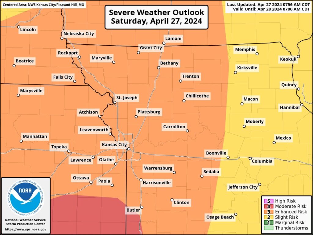
“Saturday is designated as another First Alert Weather Alert Day due to the potential for severe thunderstorms in the region, Flood Risk beginning Saturday afternoon.
The morning on Saturday will begin mostly dry, with temperatures hovering around 80 degrees. A south wind, gusting up to 35 mph, will contribute to warm and humid conditions throughout the day.”
“Thunderstorms are forecasted to develop in the afternoon, Flood Risk becoming increasingly likely in the evening, with the highest chances for severe weather expected after 6 p.m. The most intense part of the storm system is anticipated to pass through during the overnight hours, around midnight.”
It’s crucial to have multiple ways to receive severe weather alerts on Flood Risk such as a NOAA Weather Radio. In the event of a tornado warning overnight, ensure your chosen method can wake you up promptly to seek safety.
While not all storms may be severe, there’s a potential for damaging winds, large hail, and flash flooding due to heavy rainfall. There’s also a chance of a strong tornado or Flood Risk.
Flooding remains the primary concern with this round of storms into the overnight hours, especially considering the rainfall earlier in the week. A Flood Risk is already in effect until Sunday.
This round of storms is expected to exit the area around 4 a.m. Sunday, with another round anticipated around 10 a.m. This system represents the main front and should clear the area by late Sunday afternoon
Summary in table format
| Heading | Content |
|---|---|
| Severe Weather Threat | After the severe weather threat passes from the Kansas City area, the storm system lingers, posing continued risks. |
| Potential Flooding | Expect periods of heavy rain overnight into Sunday, with a Flood Watch in effect until midday Sunday. All forms of flooding are possible. |
| Morning Weather Conditions | Saturday morning begins mostly dry, with temperatures around 80 degrees and a south wind gusting up to 35 mph, leading to warm and humid conditions. |
| Thunderstorm Development | Thunderstorms are forecasted to develop in the afternoon, becoming increasingly likely in the evening, with the highest chances for severe weather after 6 p.m. |
| Importance of Severe Weather Alerts | It’s crucial to have multiple ways to receive severe weather alerts, such as a NOAA Weather Radio, to stay informed about any overnight tornado warnings. |
| Potential Hazards | While not all storms may be severe, damaging winds, large hail, and flash flooding due to heavy rainfall are possible. A strong tornado or two can’t be ruled out. |
| Concern for Flooding | Flooding remains the primary concern with this round of storms, especially considering earlier rainfall in the week. A Flood Watch is already in effect. |
| Storm Exit and Follow-up | The storm is expected to exit the area around 4 a.m. Sunday, with another round anticipated around 10 a.m., clearing by late Sunday afternoon. |


More Stories
NBA Playoff Recap: Mavericks Eliminate Clippers; Magic Extend Series to Game 7
New Movie Review: ‘The Idea of You’ – A Delightful Guilty Pleasure,2024
Groundbreaking: Orangutan Uses Medicinal Plant to Heal Wound – A World First